 Filter: Categories of Wisconsin Historical Images
Filter: FORMAT_DIMENSIONS of 22 x 36 cm.
Filter: Categories of Wisconsin Historical Images
Filter: FORMAT_DIMENSIONS of 22 x 36 cm.
| Date: | 1911 |
|---|---|
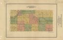
| Description: | Map shows townships and sections, roads, and railroads. "W.W. Downs, attorney-at-law, Eau Claire, Wis." |
| Date: | 1915 |
|---|---|
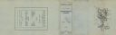
| Description: | A pamphlet of lots for sale. There are four regions represented in four sheets of the pamphlet: "Mercer's Additions," "Edgewood Park," "West Lawn Heights,"... |
| Date: | 1974 |
|---|---|
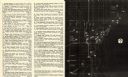
| Description: | This map of Milwaukee shows forty landmark buildings located and identified, including those on the National Register of Historic Places and the Historic A... |

| Date: | 1915 |
|---|---|
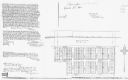
| Description: | This map shows streets and lots with prices available through the Madison Realty Company. Some of the plats include legends. The areas include: Brooks' Add... |
| Date: | 1996 |
|---|---|
| Description: | This photocopy plat map shows "old" Pennington, a village situated in section 26 of township 37 north, range 10 east, alongside the Minneapolis, Sault Ste ... |

| Date: | 1789 |
|---|---|
| Description: | Map of New York City showing ward boundaries, ferries, streets, roads, swamps, ponds, and rivers. The properties of Lispinard, Byards, Jones, Rutgers, and ... |
If you didn't find the material you searched for, our Library Reference Staff can help.
Call our reference desk at 608-264-6535 or email us at: